Archive for the ‘Hiking’ Category

BOGO Lodging to Celebrate National Parks Week

Thursday, April 8th, 2010

Let’s go BOGO. Who doesn’t love a buy one get one free lodging bargain? When it’s combined with free entrance to a U.S. National Park during the week of April 17- 25, your spring vacation is a budgetary winner. Sure, you could camp at Shenandoah or Yellowstone, but look at these bargains:

Mesa-verde-far-view-lodge

Far View Lodge

At Mesa Verde National Park in southwestern Colorado, explore the ancient cliff dwellings of a UNESCO World Heritage site. Visits to Cliff Palace, Balcony House and Long House require a ticket on a ranger-led tour. Be sure to save some time for hiking one of the many trails or visiting the Chapin Mesa Archaeological Museum. From your room at Far View Lodge, high on the mesa’s shoulder, the view encompasses three states and all the stars you can count in the dark, night sky. Rooms are priced at $99 with a consecutive night free. This offer is valid from April 22 – 30, 2010. And, entrance to Mesa Verde National Park is free through the end of April.

Experience Virginia’s beautiful spring with a stay at Skyland Resort in Shenandoah National Park. The historic resort, built in 1886, offers inspiring views of the Shenandoah Valley. But don’t spend all of your time looking out the window from the highest point on Skyline Drive — take a hike, go biking or visit one of the local wineries. Book one night for $125 and receive the second consecutive night free. Offer valid from April 18 – 29, 2010.

kalaloch-lodge-olympic-national-park

Kalaloch Lodge

Olympic National Park in Washington encompasses rain forests, rugged beaches and mountain splendor. Confused about what to see first? Why not split your visit into two Olympic experiences? First take in the rugged Pacific coastline from your accommodations at Kalaloch Lodge. The bird-watching paradise includes hiking, biking and beach-combing opportunities. Next, head 12 miles into the heart of Olympic National Forest for a stay at Sol Duc Hot Springs Resort. Soak away tired muscles after an invigorating hike through an old growth rainforest. Both Kalaloch Lodge and Sol Duc Hot Springs Resort are offering accommodations priced at $157 with a second consecutive night free. This offer is valid from April 17 – 25, 2010.

Shenandoah, Mesa Verde, Olympic — I’m having a hard time deciding which National Park BOGO lodging adventure to choose. How about you?

Photos courtesy ARAMARK Parks and Destinations.

Review by Donna L. Hull, My Itchy Travel Feet.

El Fuerte, Mexico, Turns Its Back on the River of the Same Name, but for Visitors the River Has Much to Offer

Tuesday, April 6th, 2010

Most towns founded alongside rivers face the water, but in the case of El Fuerte, Mexico, the town turns its back on the lovely river of the same name. This seems even stranger upon learning that the first white man to set foot in the area landed on the banks of the El Fuerte River, not far from the location of the present day town. Though the town’s focus is on its beautiful central square and colonial era restored buildings, visitors to the area should spend at least a few hours discovering the river, which has flowed continuously for a millennium on a 270-mile journey that begins high in the Sierra Tepehuanes Mountains in Durango until it empties into the Sea of Cortez.

Half-mile River Walk along the El Fuerte River

Begin by walking down the hill on The 16th of Septiembre Street. At the river, turn right onto the broad paver stone walkway that parallels the river for half a mile. At the end of the official River Walk, continue on the dirt street, winding down the hill for about a mile, always choosing the route closest to the river. Bird watchers will find this area particularly rich in avian species, especially early in the morning.

Cross the swinging bridge and continue on the path to see the ancient petroglyphs carved into boulders along the banks. Located about two miles down the path, the petroglyphs are believed to be Nahuatl in origin, the same race as the Aztecs. Visitors can seek out this ancient graffiti by themselves, or hire one of many local guides who will be happy to provide a half-day tour that combines bird watching with a hike to the rocks, or can arrange for canoe or rafting trips on the river.

Further upriver is the Miguel Hidalgo Dam, built in the mid-1950’s. Although the main reason for the dam was to provide water to the valley of El Fuerte for agricultural purposes, the lake also offers magnificent black bass fishing. Additionally, thermal hot springs are found in the village of Jiparo, near the Hidalgo Dam.

Photo Credit: Barbara Weibel
Article by Barbara Weibel of Hole In The Donut Travels

Oro Valley, Arizona

Monday, April 5th, 2010
A path among the yet-to-bloom mesquite trees in Catalina State Park.

A path among the yet-to-bloom mesquite trees in Catalina State Park.

A few weekends ago my husband and I drove about an hour and a half south of where we live, to an area just north of Tucson known as Oro Valley. Among other things, we wished to hike the Catalina State Park. So we got up early on Saturday morning, showered and packed and did all the things homeowners (and pet owners) do when they’re going to be gone for a 24-hour period of time.

We arrived at the CSP right at noon – which, upon reflection, wasn’t the best time of day to start our hike. The 68-degree weather was lovely, but the breeze barely provided a defense against the direct sunlight and lack of shade. Plus, the harsh sunlight is not ideal for photography. Still, we weren’t altogether miserable, were sun-blocked up, and had plenty of water. So after a cursory look at the “Wildlife Display” (which featured a half dozen various snakes, a few gila monsters, and some pelts) we addressed the trail map and set off.

I wrote a recent entry about our hiking experience, along with my first attempt at a video blog, which you can view here.

We stayed at the Oro Valley Holiday Inn Express, which was just a short distance away from the park. We checked in, and lugged our stuff to our room. The first thing my husband does whenever he enters any hotel room is immediately turn on the A/C, which is when we discovered that it was a very noisy, very unhappy little A/C unit. So we got cleaned up (and had to deal with a very uncooperative shower head) and changed our clothes and re-packed, then requested that we be moved to a different room with a functional A/C. They were happy to oblige (despite the fact that they had to re-clean the bathroom of our original room – I kind of felt bad about that), and fortunately we pack light. The second room’s A/C worked fine, but the shower head was just as wonky, and it turned out that the bedsprings had serious poke-through issues. So! While I would recommend the Holiday Inn Express as a chain, our experience at this particular hotel was less than stellar. The staff was great, though, and the rooms were clean and neat.

Saturday night’s dinner was at the Hi Falutin’ Rapid Fire Western Grill. My husband ordered a fillet, I ordered the shredded beef tacos, and OH MY GOD, was that food INCREDIBLE. I didn’t bring my camera in, else I surely would have embarrassed us with all the pictures I’d have taken of our plates.

After dinner, we drove back over to the hotel, parked, and walked across to the neighboring Taste of Chicago. We occupied a table on the patio for several hours, watching the light change on the mountains.
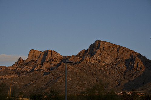
View of the Catalina Mountains from the Taste of Chicago patio.

View of the Catalina Mountains from the Taste of Chicago patio.

We talked and sipped our drinks and took pictures. I happened to be sitting facing the gully that runs alongside the restaurant, and saw a pair of rabbits go racing by. My “Oh, bunnies!” exclamation caused my husband to look in the opposite direction to see what the bunnies were running from. He leaped up from the table and said, “Holy crap, it’s a bobcat! Quick, gimme the camera!”

The bobcat is in the center of the photo.  Click to enlarge!

The bobcat is in the center of the photo. Click to enlarge!

He chased off along the fence, camera in hand, being all “here kitty kitty” while the bobcat disdained his efforts. Eventually my husband came back tot he table, mourning the lack of a telephoto lens – he never was able to get close enough to get a really clear picture. Then, in a fit of wildlife photography inspiration, he proceeded to attempt to capture the flitting efforts of a bat, who had come out early to partake of the bugs.

The bat - click on it to see it in a larger size.  It's actually a pretty cool shot.

The bat - click on it to see it in a larger size. It's actually a pretty cool shot.

We ended up hanging out on the patio for several hours, watching the stars come out and enjoying the live entertainment the restaurant provided for the evening.

We checked out of the hotel the next morning by about 9:30, and headed in the general direction of Phoenix. We came across the type of mom-and-pop breakfast place we were hoping for, the Sunny Side Up Cafe. Lots of bikers and truckers, and a packed parking lot on a Sunday morning, which was all the assurance we needed that this local place was good. The place was standing room only, so we opted for seats at the counter, which I always enjoy anyway. I like observing the well-oiled machine that is a good diner. The coordination between the prep station, cooks, and wait staff was flawless. They kept up the snarky banter the whole time, too, which was entertaining while we noshed on our corned beef hash and eggs.

We took Route 71 back to the Valley, passing the Tom Mix monument and wash. I asked my husband who he was (hubby’s an Arizona native, so I figured he’d know), and he said he couldn’t remember and thought he was some sort of an outlaw cowboy. I looked it up when we got home. Come to find out he was an actor who occasionally played an outlaw cowboy. So my husband’s memory wasn’t entirely inaccurate.

All in all it was a lovely weekend getaway.

Photo credits (all): Tiffany Joyce.

A Basic Guide to Odiorne Point State Park in New Hampshire

Thursday, April 1st, 2010

From early American settlers to World War II, the land that is now Odiorne Point State Park has played an important role this country’s history.

Ships from Europe landed here in 1623, and in 1660, John Odiorne joined the settlement and acquired enough land to begin a full-fledged community. Following the Civil War, the area became a popular seaside resort area in the northeast.

WWII saw the land taken over for the building of Fort Dearborn, which helped to protect the harbor of nearby Portsmouth and its naval shipyard. It was sold to the state of New Hampshire for $91,000 in 1961, and was then turned into a state park.

Today, the land functions as a day-use park for the city of Portsmouth. It is also home to the Seacoast Science Center.

The Rocky Coastline of Odiorne Point State Park

Nearest major city: Portsmouth, New Hampshire (15 miles west)

Famous for: Odiorne Point was the first settlement in what would later become the state of New Hampshire.

Admission: $4/adults; $2/children 6-12; Free under age 6

Families with children will like: Exploring the military remnants of Fort Dearborn.

Other travelers will like: The park does have nature trails to explore, both on foot and bicycle.

Also, just off the coast, barely visible during low tide, are the ancient remains of a sunken forest. Certified scuba divers can explore these 3,500-4,000 year old trees that became submerged when the glaciers melted during the last ice age.

Easy sightseeing: Visitors to the Seacoast Science Center are welcome to touch and learn about tide pool animals in the indoor touch tank, watch deep ocean fish swim the the one thousand-gallon Gulf of Maine tank, and follow nearly four centuries of local history on an interactive timeline.  Admission fees are $5/adult and $2/children age 12 and under.

Camping information: Because this is a day-use state park, there are no campsites or other lodging within the park’s boundaries.

Other nearby lodging: Portsmouth has everything from campgrounds to luxury hotels for travelers to choose from.

Best months to visit for weather: Late spring and early fall are best for moderate temperatures.

Best months to visit to avoid crowds: Peak tourist seasons are the summer months. Spring and fall weekdays are probably the best if looking to avoid crowds.

Nearest major airport: Portsmouth, NH

More info can be found at: New Hampshire Division of Parks and Recreation

Related posts:

[Photo courtesy of New Hampshire Division of Parks and Recreation]

Mount Greylock State Reserve, Massachusetts

Wednesday, March 31st, 2010

mount greylock state reserve

The view from Mount Greylock, MA

Intro: Out in the Berkshires (the western part of the state) rises Mount Greylock, the highest point in Massachusetts. Mount Greylock State Reserve is the historic state’s first wilderness state park, established in 1898. Spread across six towns (Adams, Cheshire, Lanesborough, New Ashford, North Adams and Williamstown), it’s classic rural New England — wild, yet just steps away from civilization.

Famous for: Mount Greylock, the highest peak in Massachusetts

Admission: Free, with a $2 parking fee for parking lot only. Parking is free for ParksPass  holders, vehicles with Handicapped, disabled veteran plates/placard, and seniors 62 and above with the Massachusetts Senior Pass.

Families with young kids will like: the Visitor Center with nature and science exhibits, and accessible restrooms

Families with teenagers will like: Awesome mountain biking trails

Other travelers will like:

  • 70 miles of designated trails for hiking, including an 11.5 mile section of the Appalachian National Scenic Trail
  • winter sports like back-country skiing, snowshoeing and snowmobiling
  • bird watching
  • hunting in season

Easy site seeing: Drive all the way to the summit and enjoy the sunset from the porch at Bascom Lodge. Be sure to make reservations for the fixed price dinner, if you’re lucky there will be blueberry something for dessert!

Best hotel in the park: Bascom Lodge at the summit. Drive up, enjoy the enclosed porch (important during black fly and mosquito seasons!) and they even have wifi!

Best campground in the park: This is not car camping, my friends. There is a “primitive” campground that you hike into, as a well as five trailside backpack shelters, and you hike into all of them. There are 15 tent sites, 7 group site, and you need to make reservations from April1 through November 1.

Worst lodging experience: You are in black bear country. Do not leave out food, and hopefully you’ll never find out about the worst experience.

Best months to visit for weather: April through October — early fall is stunningly gorgeous, although it can get cold fast!

Best months to visit to avoid crowds: Late spring, early fall

Nearest major cities:

  • Lenox, MA
  • Springfield, MA

More info can be found at: http://www.mass.gov/dcr/parks/mtGreylock/

Related posts:

Photo courtesy of: MA Department of Conservation and Recreation

Mount Washington State Park

Wednesday, March 31st, 2010
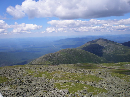
The view from Mount Washington.

The view from Mount Washington.

Mount Washington, located on Route 302 near North Conway, New Hampshire, achieves a height of over 6,200 feet. While that might not be the tallest mountain you’ve ever heard of, its location on the East Coast of the United States at the convergence of several storm tracks affords it with some pretty wicked weather conditions, and one of the highest recorded wind speeds to date – 231 miles per hour, recorded on April 12, 1934.

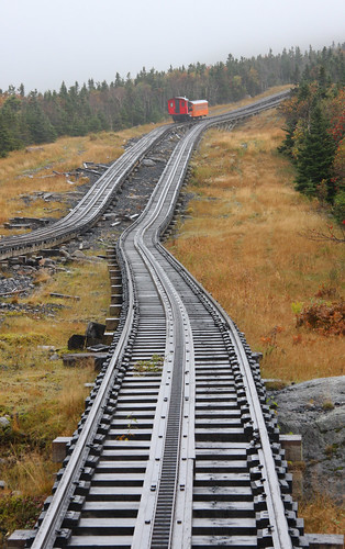
The 59 acres surrounding and including the summit comprise the Mount Washington State Park, while the park itself is surrounded by the 750,000-acre White Mountain National Forest. The park is accessed by an eight mile long, winding and steep roadway up from the base of the mountain. Visitors can also park at the bottom and ride the Mt. Washington Cog Railway, which was the first rack-and-pinion mountain-climbing cog railway. The three mile railroad journey remains one of the steepest in the world. On a clear day views from the summit can extend as far as Vermont, New York, Quebec, Massachusetts, Maine and the Atlantic Ocean.

The Mount Washington Cog Railway

The Mount Washington Cog Railway

The summit park includes a cafeteria, restrooms, gift shops, the Mt. Washington Observatory and its museum. The area is famous – and sometimes infamous – for its hiking. There are more than fifteen trails that lead up Mt. Washington, and they are primarily rough and steep. Hikers are encouraged to acquire AMC White Mountain Guides, found at the Appalachian Mountain Club’s (AMC) Pinkham Notch Camp, for trail information and a map before heading out.

Admission is $4.00 for adults, $2.00 for children ages 6-11, and free for children ages 5 & under, and NH residents age 65 & over. The season runs from mid-May to mid-October from 10:00 a.m. to 4:00 p.m. The park is not open on days of heavy rains or high winds. The best months for weather to visit the park are July and August, while the least crowded months are May and October.

Lodging is available at the Mount Washington Hotel & Resort, with plenty of other lodging and entertainment opportunities available in nearby Bretton Woods.

Photos courtesy of: JCardinal, and Exfordy, on Flickr Creative Commons.

A Basic Guide to Porcupine Mountains Wilderness State Park in Michigan

Tuesday, March 30th, 2010

Located in the Upper Peninsula section of Michigan is the Porcupine Mountains, a group of small mountains near the shore of Lake Superior. “The Porkies,” as the locals call them, were named by the native Ojibwa tribe due to their shape, which they thought resembled a porcupine.

Porcupine Mountains Wilderness State Park was the site of copper mining in the 19th century. Today, visitors come to explore the miles of hiking trails that wind through the mountains, as well as The Lake Superior water trail that forms the northern edge of the park and is best seen via canoe or kayak.

One of the Waterways within Porcupine Mountains Wilderness State Park

Nearest major city: Duluth, Minnesota and Green Bay, Wisconsin are the closest. Each is about 200 miles from the park.

Famous for: The Porcupine Mountains are home to the most extensive span of old growth northern hardwood forest in North America west of the Adirondack Mountains.

Admission: $6/vehicle per day

Families with children will like: Exploring all the hiking trails. Spotting for wildlife – black bears are plentiful in this park.

Other travelers will like: Fishing (license required) on either Lake Superior or Lake of the Clouds within the park.

Music lovers will enjoy the Porcupine Mountains Music Festival, held at the end of August. This three-day event offers the finest folk, bluegrass, blues and cajun/zydeco music.

Easy sightseeing: Try the wooden boardwalk trail that leads to an overlook at Lake of the Clouds. .

Camping information: There are several campgrounds ranging from basic tent-only to those that offer RV sites with electric hookups. Rates range from $14-$25/night.

Other park lodging: The campgrounds also offer several cabins for rent, as well as a few furnished yurts, at $60/night.

The Kaug Wudjoo Lodge inside the park is a single group lodging that sleeps up to 12 and rents for $1225/week. Call 906-885-5275 for more details.

Other nearby lodging: The small towns of Silver City and Ontonagon, Michigan, have a small selection of motels/hotels to choose from.

Best months to visit for weather: Late spring and early fall are best for moderate temperatures. Fall is best for the changing colors of the leaves.

Best months to visit to avoid crowds: Peak tourist seasons are the summer months. Spring and fall weekdays are probably the best if looking to avoid crowds.

Getting here:

  • Flying – Houghton County Memorial Airport is serviced by Delta regional flights. Green Bay, Wisconsin (200 miles south) is the nearest major airport for more flight options

More info can be found at: Michigan Dept. of Natural Resources

Related posts:

[Photo courtesy of Michigan Dept. of Natural Resources]

A Basic Guide to Swallow Falls State Park in Maryland

Tuesday, March 30th, 2010

In the northwest corner of the state of Maryland, where it meets up with the states of West Virginia and Pennsylvania, is where you’ll find Swallow Falls State Park.

The Youghiogheny River flows along the park’s borders, creating rocky gorges, rapids and waterfalls, including Muddy Creek Falls. The park is also home to the oldest grove of white pine and eastern hemlock trees in Maryland.

Muddy Creek Falls at Swallow Falls State Park

Nearest major city: Oakland, Maryland. Within a 2-3 hour radius are: Baltimore, MD; Pittsburgh, PA; and Morgantown, WV

Famous for: At 53 feet tall, Muddy Creek Falls is Maryland’s highest waterfall. In the early 20th century inventor Thomas Edison would often camp here.

Admission: $3/person

Families with children will like: Fishing and the hiking trails. Teens will enjoy the mountain bike trails.

Other things travelers will like: The falls are great for photography buffs. In the winter, snowmobiling is popular.

Camping information: Swallow Falls State Park offers 65 wooded campsites, including some with electric/water/sewer hookups. $25/night without hookups; $35/night with. The campground is closed from December 15 through April 15 annually.

Other park lodging: The campground offers camper cabins for rent that sleep four, with outdoor grills and communal restroom/shower facilities. They’re only available from Memorial Day until Labor Day, for $50/night.

Other nearby lodging: The nearby Deer Creek Lake resort community of Oakland has a wide variety of lodging to choose from.

Best months to visit for weather: Late spring and early fall are best for moderate temperatures. Fall is best for the changing colors of the leaves.

Best months to visit to avoid crowds: Peak tourist seasons are the summer months. Spring and fall are probably the best if looking to avoid crowds.

Getting here:

  • Flying – Baltimore and Pittsburgh are both serviced by many airlines, but you’ll definitely need a car to get here..

More info can be found at: Maryland Dept. of Natural Resources

Related posts:

[Photo courtesy of Maryland Dept. of Natural Resources]

A Basic Guide to Petit Jean State Park in Arkansas

Monday, March 29th, 2010

When it comes to the natural beauty of Arkansas’ mountain region, Petit Jean State Park seems to embody it all. From forests threaded with streams to the spectacular Cedar Falls, the park is a natural paradise. One will also find red rock bluffs, canyons, caves and natural stone bridges among the park’s many hiking trails.

The park is also home to the grave of Petit Jean (hence the name), who according to legend is a French girl who disguised herself as a boy named “Little John” to accompany her sweetheart out west in the 1700s. When she became ill and passed away, she was buried under the French version of that name – “Petit Jean.”

Certain areas of the park also are designated an archaeological historical site due to the bluff shelters along the Rock House Cave trail that were used by Native Americans that once lived here.

The Man-Made Davies Bridge at Petit Jean State Park

Nearest major city: Little Rock, Arkansas (60 miles southeast)

Famous for: Arkansas’ first state park, it was opened in 1923.

Admission: Free

Families with children will like: There are many hiking trails in the park, ranging from moderate to slightly strenuous. The park also offers two playground areas for younger children.

The Annual Mountain Rendezvous festival in the fall is also fun for families. Co-sponsored by the Early Arkansaw Reenactor Association, it features demonstrations of rifle loading, tomahawk throwing, and other survival skills used by the mountain pioneers of yore.

Other travelers will like: Fishing (license required) and boating (rentals available for additional fee) on Lake Bailey. Bird watching is also popular in this park.

Easy sightseeing: Try the Mountain Top driving tour that includes several sightseeing stops and overlooks.

Camping information: The park offers 125 individual campsites among four campgrounds. All have water/electric hookup ($18/night); some have 50amp electric/sewer hookups ($28/night).

For those without a tent, the park has two sites fully furnished with a tent and sleeping equipment and two teepee sites fully furnished with sleeping equipment that sleep up to six. These rent for $50/night.

Other park lodging: Mather Lodge offers 24 guest rooms with either 1 queen bed ($65/night) or 2 doubles ($70/night). Two rooms are disabled accessible. All have TVs with satellite, coffee pot and iron, but no telephones. This is also where you’ll find the park’s restaurant.

Near Mather Lodge are 41 cabins of various sizes to rent. These come fully equipped with electric kitches, air conditioning/electric heat, linens and cooking utensils/tableware. Twelve more kitchenless duplex cabins are nearby. Some are ADA accessible. Rates range from $75/night to $175/night (comes with private hot tub) per couple. Additional guests are $10/person over age 12.

Other nearby lodging: Nearby Morrilton has a variety motels/hotels to choose from.

Best months to visit for weather: Late spring and early fall are best for moderate temperatures. Fall is best for the changing colors of the leaves.

Best months to visit to avoid crowds: Peak tourist seasons are the summer months. Spring and fall are probably the best if looking to avoid crowds.

Getting here:

  • Flying – Little Rock is the closest major airport, but the park has its own airport for those that wish to fly themselves in. Call 501-727-5441 for aviation details.

More info can be found at: Arkansas State Parks official website

Related posts:

[Photo courtesy of Arkansas State Parks]

A Basic Guide to Crater of Diamonds State Park in Arkansas

Monday, March 29th, 2010

If diamonds are a girl’s best friend, then Crater of the Diamonds State Park in Arkansas is perfect for an outdoorsy girlfriends getaway with the family.

That is because the park is the only diamond-producing site in the world open to the public. Visitors the park get to mine for diamonds and other precious gems, like lamproite, amethyst, banded agate, jasper, peridot, garnet, quartz, calcite, barite, and hematite. It’s finders-keepers here, too, regardless of the market value of your find.

Most gems are small finds, but there have been the occasional big ticket finds of 5 carats or more.

The Entrance to Crater of Diamonds State Park

Nearest major city: Murfreesboro, Arkansas (5 miles southwest)

Famous for: World’s only diamond mine open to the public.

Admission: $7/adults; $4 children ages 6-12; Free under 6. Diamond sifting tools may be brought in or rented at the park for an additional fee.

Families with children will like: Sifting for the diamonds and other precious gems. The park doesn’t allow motorized equipment, so the tools like sifting boxes are appropriate for kids of all ages.

Younger children will also enjoy the mining-themed aquatic playground (essentially a big pool with kid-sized waterslides) on a hot day. There is an additional fee for this of $5.50/adult; $3.75/children.

Other travelers will like: Fishing on the Missouri River (license required); hiking the park trails

Camping information: The park offers 59 campsites with water and electric hookups. There are also hot showers, a laundromat and dump station. The campground is closed for renovations until mid-summer 2010. Once reopened, rates are $18/night.

Other nearby lodging: There are no additional lodging facilities within the park, but nearby Murfreesboro has a variety of accommodations available from campgrounds to motels/hotels.

Best months to visit for weather: Late spring and early fall are best.

Best months to visit to avoid crowds: Peak tourist seasons are the summer months. Spring and fall are probably the best if looking to avoid crowds.

Getting here:

  • Flying – Little Rock, Arkansas, is the closest major airport

More info can be found at: Arkansas State Parks official website

Related posts:

[Photo courtesy of Arkansas State Parks]